AI Insights
Bluesky blocks Mississippi due to its new age verification law

Users with Mississippi IP addresses can no longer access the Bluesky app. The decentralized social media network has explained in a post that Mississippi’s new age verification law for social networks “would fundamentally change” how it operates, and it wouldn’t be possible to comply with its small team and limited resources.
Bluesky says that while it does follow the UK’s Online Safety Act, it works very differently from Mississippi’s approach to age verification. In the UK, it’s only required to check for a user’s age if they’re accessing certain content and features. In Mississippi, however, it cannot allow anyone to access its service at all, unless they hand over sensitive data proving how old they are. Further, the platform will be required to keep track of which users are children under 18, and it will be responsible for making sure those users won’t be able to access “harmful materials.” Earlier this month, the Supreme Court decided not to intervene with the legislation, allowing it to go into effect.
The service says that it doesn’t have the significant resources needed to be able to build the required “verification systems, parental consent workflows and compliance infrastructure.” In addition, it could be penalized with up $10,000 per user if the government finds it to be non-compliant. Because only big tech companies can afford the costs associated with those requirements, Bluesky says the “dynamic entrenches existing big tech platforms while stifling the innovation and competition that benefits users.”
Bluesky will now show a note to any user accessing the service from Mississippi, telling them why it’s no longer available in the state.


Google DeepMind introduced a new artificial intelligence model that captures the vivid details of the Earth’s surface, which helps scientists and governments make better decisions about the land and sea.
AI Insights
Artificial intelligence to make professional sports debut as Oakland Ballers manager – CBS News

AI Insights
‘It is a war of drones now’: the ever-evolving tech dominating the frontline in Ukraine | Ukraine
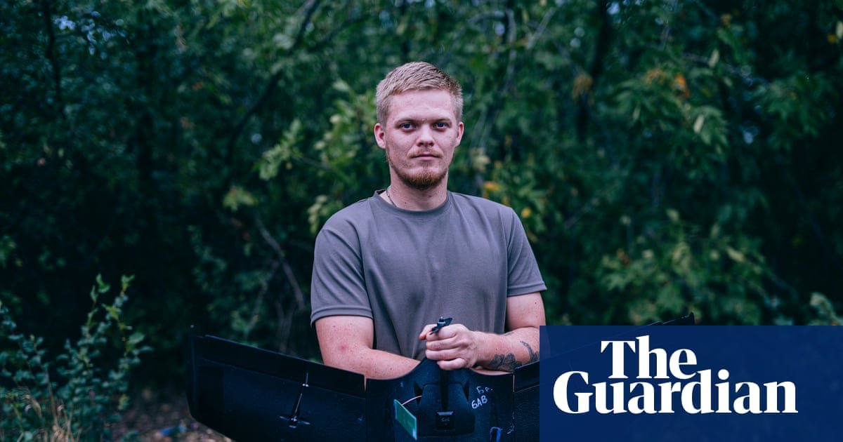
“It’s more exhausting,” says Afer, a deputy commander of the “Da Vinci Wolves”, describing how one of the best-known battalions in Ukraine has to defend against constant Russian attacks. Where once the invaders might have tried small group assaults with armoured vehicles, now the tactic is to try and sneak through on foot one by one, evading frontline Ukrainian drones, and find somewhere to hide.
Under what little cover remains, survivors then try to gather a group of 10 or so and attack Ukrainian positions. It is costly – “in the last 24 hours we killed 11,” Afer says – but the assaults that previously might have happened once or twice a day are now relentless. To the Da Vinci commander it seems that the Russians are terrified of their own officers, which is why they follow near suicidal orders.
Reconnaissance drones monitor a burnt-out tree line west of Pokrovsk; the images come through to Da Vinci’s command centre at one end of a 130-metre-long underground bunker. “It’s very dangerous to have even a small break on watching,” Afer says, and the team works round the clock. The bunker, built in four or five weeks, contains multiple rooms, including a barracks for sleep. Another is an army mess with children’s drawings, reminders of family. The menu for the week is listed on the wall.
It is three and a half years into the Ukraine war and Donald Trump’s August peace initiative has made no progress. Meanwhile the conflict evolves. Afer explains that such is the development of FPV (first person view) drones, remotely piloted using an onboard camera, that the so-called kill zone now extends “12 to 14 kilometres” behind the front – the range at which a $500 drone, flying at up to 60mph, can strike. It means, Afer adds, that “all the logistics [food, ammunition and medical supplies] we are doing is either on foot or with the help of ground drones”.
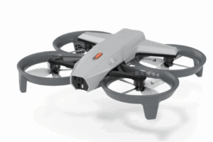
Further in the rear, at a rural dacha now used by Da Vinci’s soldiers, several types of ground drones are parked. The idea has moved rapidly from concept to trial to reality. They include remotely controlled machine guns, and flat bed robot vehicles. One, the $12,000 Termit, has tracks for rough terrain and can carry 300kg over 12 miles with a top speed of 7 miles an hour.
Land drones save lives too. “Last night we evacuated a wounded man with two broken legs and a hole in his chest,” Afer continues. The whole process took “almost 20 hours” and involved two soldiers lifting the wounded man more than a mile to a land drone, which was able to cart the victim to a safe village. The soldier survived.
While Da Vinci reports its position is stable, endless Russian attempts at infiltration have been effective at revealing where the line is thinly held or poorly coordinated between neighbouring units. Russian troops last month penetrated Ukraine’s lines north-east of Pokrovsk near Dobropillya by as much as 12 miles – a dangerous moment in a critical sector, just ahead of Trump’s summit with Vladimir Putin in Alaska.
At first it was said a few dozen had broke through, but the final tally appears to have been much greater. Ukrainian military sources estimate that 2,000 Russians got through and that 1,100 infiltrators were killed in a fightback led by the 14th Chervona Kalyna brigade from Ukraine’s newly created Azov Corps – a rare setback for an otherwise slow but remorseless Russian advance.
That evening at another dacha used by Da Vinci, people linger in the yard while moths target the light bulbs. Inside, a specialist drone jammer sits on a gaming chair surrounded by seven screens arranged in a fan and supported by some complex carpentry.
It is too sensitive to photograph, but the team leader Oleksandr, whose call sign is Shoni, describes the jammer’s task. Both sides can intercept each other’s feeds from FPV drones and three screens are dedicated to capturing footage that can then help to locate them. Once discovered, the operator’s task is to find the radio frequency the drone is using and immobilise it with jammers hidden in the ground (unless, that is, they are fibre optic drones that use a fixed cable up to 12 miles long instead of a radio connection).
“We are jamming around 70%,” Shoni says, though he acknowledges that the Russians achieve a similar success rate. In their sector, this amounts to 30 to 35 enemy drones a day. At times, the proportion downed is higher. “During the last month, we closed the sky. We intercepted their pilots saying on the radio they could not fly,” he continues, but that changed after Russian artillery destroyed jamming gear on the ground. The battle, Shoni observes, ebbs and flows: “It is a war of drones now and there is a shield and there is a sword. We are the shield.”
A single drone pilot can operate 20 missions in 24 hours says Sean, who flies FPVs for Da Vinci, for several days at a stretch in a crew of two or three, hidden a few miles behind the frontline. Because the Russians are on the attack the main target is their infantry. Sean frankly acknowledges he is “killing at least three Russian soldiers” during that time, in the deadly struggle between ground and air. Does it make it easier to kill the enemy, from a distance? “How can we tell, we only know this,” says Dubok, another FPV pilot, sitting alongside Sean.
Other anti-drone defences are more sophisticated. Ukraine’s third brigade holds the northern Kharkiv sector, east of the Oskil River, but to the west are longer-range defence positions. Inside, a team member watches over a radar, mostly looking for signs of Russian Supercam, Orlan and Zala reconnaissance drones. If they see a target, two dash out into fields ripe with sunflowers to launch an Arbalet interceptor: a small delta wing drone made of a black polystyrene, which costs $500 and can be held in one hand.
The Arbalet’s top speed is a remarkable 110 miles an hour, though its battery life is a shortish 40 minutes. It is flown by a pilot hidden in the bunker via its camera using a sensitive hobbyists’ controller. The aim is to get it close enough to explode the grenade it carries and destroy the Russian drone. Buhan, one of the pilots, says “it is easier to learn how to fly it if you have never flown an FPV drone”.
It is an unusually wet and cloudy August day, which means a rare break from drone activity as the Russians will not be flying in the challenging conditions. The crew don’t want to launch the Arbalet in case they lose it, so there is time to talk. Buhan says he was a trading manager before the war, while Daos worked in investments. “I would have had a completely different life if it had not been for the war,” Daos continues, “but we all need to gather to fight to be free.”
So do the pilots feel motivated to carry on fighting when there appears to be no end? The two men look in my direction, and nod with a resolution not expressed in words.
-

 Business1 week ago
The Guardian view on Trump and the Fed: independence is no substitute for accountability | Editorial
-
Tools & Platforms4 weeks ago
Building Trust in Military AI Starts with Opening the Black Box – War on the Rocks
-

 Ethics & Policy1 month ago
SDAIA Supports Saudi Arabia’s Leadership in Shaping Global AI Ethics, Policy, and Research – وكالة الأنباء السعودية
-

 Events & Conferences4 months ago
Journey to 1000 models: Scaling Instagram’s recommendation system
-

 Jobs & Careers2 months ago
Mumbai-based Perplexity Alternative Has 60k+ Users Without Funding
-
 Education2 months ago
VEX Robotics launches AI-powered classroom robotics system
-

 Podcasts & Talks2 months ago
Happy 4th of July! 🎆 Made with Veo 3 in Gemini
-

 Funding & Business2 months ago
Kayak and Expedia race to build AI travel agents that turn social posts into itineraries
-

 Education2 months ago
Macron says UK and France have duty to tackle illegal migration ‘with humanity, solidarity and firmness’ – UK politics live | Politics
-

 Podcasts & Talks2 months ago
OpenAI 🤝 @teamganassi